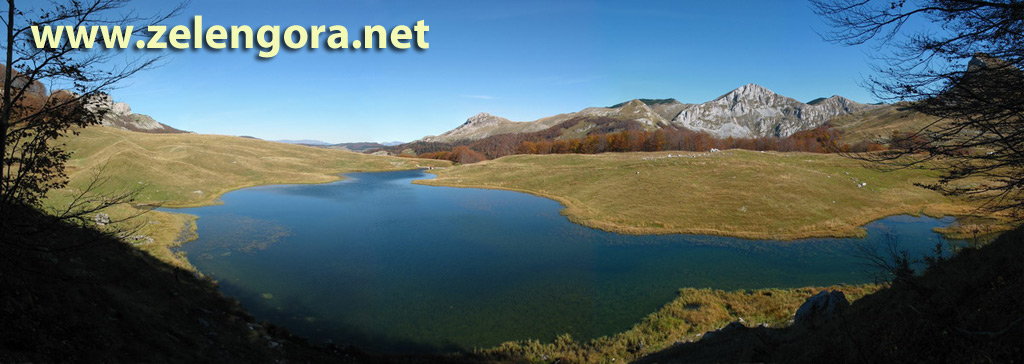
LAKES OF ZELENGORA
Zelengora Mountain is unique for its glacial lakes that create the special beauty of this mountain massif. Each lake has its own story and charm.
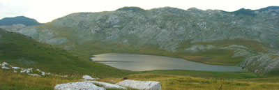
Black Lake
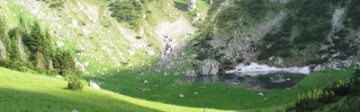
After traveling twenty kilometers from Foča towards Tjentište, you need to leave the asphalt road and turn right towards the village of Vrbnica. The turn is currently marked with a prepared signpost. The village is reached by a 13-kilometer gravel road. The first 5 kilometers, to the place called Štavanj, the road leads through the village, so you should ignore side turns and stick to the main road. The next intersection is 2 kilometers before Vrbnica. Here you should ignore the right branch of the road that descends into the stream towards the village of Ljubina and continue straight. The small tunnel you pass through after the intersection confirms that you are on the right path. To continue from the village to Srijemušna Luka (about 7.5 km), an off-road vehicle is essential. On this section too, after six kilometers there is a right turn that leads to Pašina Poljana. Our path continues straight for another kilometer or a little more. In any case, the first small bridge you encounter marks the end of the drive. The place is called Srijemušna Luka. Just before the bridge, along the left bank of the stream, we notice the path to Videž. We cross the small bridge and immediately after crossing we leave the gravel road and turn right. From this place to the lake takes 30-40 minutes on an unmarked trail through the forest. You need to follow the path previously made by machines for log extraction and not turn until we emerge onto a smaller plateau through which a small stream flows. Since the stream flows out of the lake, following its course upstream we will soon see the lake. The lake is overgrown with forest, has a muddy bottom and is increasingly overgrown with lake grass and reeds, so swimming is not possible. Next to the lake itself there is a spring that feeds the lake. The lake's surface area is about 1.08 hectares, and the maximum depth is 4 meters.
📊 Lake Data
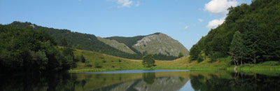
White Lake (Green Lake)
White Lake, also known as Green Lake, is located in the immediate vicinity of Black Lake. From the west and southwest, it is enclosed by the slopes of Orlovec and Orlovača, while towards the southeast, it opens with a steep slope towards Ljubin Grob. It has a surface area of about 0.70 hectares and is 3.8 meters deep. It is suitable for swimming.
📊 Lake Data

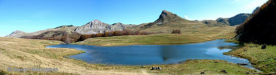
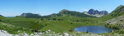
Orlovačko Lake
From the Foča - Gacko road, at the Čemerno pass, turn right. The nearby small village is reached by winding asphalt, and then you go on a gravel road, first through forested areas, and after that picturesque pasture areas will appear. After about twenty kilometers, you reach a pass from which the descent to the lake begins. This pass is also interesting because a mountain trail to Kotlaničko and Štirinsko lakes starts from it. As soon as we start descending, the slopes of Stog will appear before us, and we will also see Borilovačko, or Jugovo lake. A few hundred meters before Orlovačko Lake itself, there is a hunting lodge managed by Sutjeska National Park. Access to these lakes is also possible from the direction of Kalinovik, and the length of this road is approximately the same as from the direction of Čemerno (about 25 km), except that this road is in much worse condition because it is used for timber transport, so it is usually passable only for off-road vehicles. Orlovačko Lake is located in a grassy valley below Orlovec to the northeast and Stog to the south. Next to the lake itself there is a spring that flows into the lake. It has a surface area of about 3.50 hectares, and the maximum depth of the lake is about 5.50 meters. The lake is suitable for swimming.
From this lake it is possible to climb several peaks: Stog, Ljeljen, Orlovec, Videž, Kalelija, Todor, Kozje Strane, Bregoč and others.
📊 Lake Data
Jugovo Lake
An artificial lake, created by damming a stream that naturally formed a smaller lake at that location. It is situated at the foot of Kalelija peak.
📊 Lake Data

Kotlaničko Lake
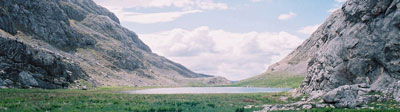
From the pass above Orlovačko and Borilovačko lakes, a mountain trail starts from the gravel road towards Kotlaničko Lake. The trail is marked, although the markings are lost on grassy surfaces, but the trail can be spotted without major difficulties. This lake of exceptional beauty is missed by many who come to Orlovačko, as it is unjustifiably considered remote and inaccessible. On the contrary, the part of the path that needs to be covered before seeing the lake makes for a real and pleasant walk through an unusual, almost lunar landscape. It takes about an hour of walking to reach this place, and the elevation difference that needs to be overcome is insignificant considering it's a mountain area. Since the lake is located in a wide valley, an additional thirty minutes is needed to descend to the lake itself. Those who don't want to can continue further towards the hill where there is a large group of medieval tombstones (stećci), from which Štirinsko Lake can also be seen. Kotlaničko Lake has a surface area of about 3.00 hectares, is 10.80 meters deep and is suitable for swimming.
Water from this lake springs at Pridvorički Spring which flows into the Neretva River. There is a spring next to the lake.
📊 Lake Data
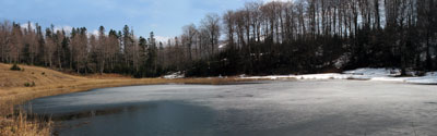
Štirinsko Lake
This lake is the largest lake on Zelengora by surface area (about 4.00 hectares), but is also the shallowest. The maximum depth is about 2 meters. The lake is not very suitable for swimming because it is mostly quite shallow and shallow for a long time near the shore, and is predominantly muddy-bottomed. In the immediate vicinity of the lake are the remains of the katun settlement of Štirine. Although several peaks over 1700 and 1800 meters rise around the lake, one has the feeling of being in a gently hilly environment, because the lake itself is located at an altitude of 1672 meters above sea level.
In the immediate vicinity of the lake are the remains of the katun settlement of Štirine.
📊 Lake Data
Donje Bare Lake
Just before Tjentište from the direction of Foča, at the bridge over the Hrčavka river, the road branches off to the right. As soon as you pass the houses along the road itself, you come across a barrier. The entrance to the National Park costs 5.00 KM per person and the same amount per car. After 4-5 kilometers, we leave the poor asphalt road that turns left towards Ozren and continue straight. You should also pay attention to the next intersection you come across. The right branch of the road leads along Hrčavka towards Dobro Dolo and Ljubin Grob, and the left continues further towards Bare. Next to the lake itself are the ruins of a once representative building and a newly built hunting lodge, the same as on Orlovačko Lake. The lake is beautiful, although the trail that surrounds it is neglected and overgrown in one part where there is usually a convenient place for swimming. Next to the lake itself there is a spring. The lake has a surface area of about 2.8 hectares and a depth of about 4 meters.
📊 Lake Data
Gornje Bare Lake
A couple of kilometers before Donje Bare, turn right, taking a short path through the forest, to the beginning of the meadow where the road ends. The lake is located at the top of the meadow, right below Ugljišin Peak, against which Tovarnica leans in extension. It covers an area of about 2 hectares and is about 3.5 meters deep. The lake is suitable for swimming.
📊 Lake Data
Kladopoljsko Lake
This enchanting lake whose bottom is covered with boulders, and in whose vicinity there is not a single tree, is located at the foot of the Zelengora and Lelija mountains. It can freely be said this way because these two mountains simply naturally form one whole with their relief, so many call Lelija the highest peak of Zelengora. It was created when shepherds from that area blocked a sinkhole into which a small stream was disappearing with cut tree trunks. The shortest approach is from the direction of Kalinovik, on the road towards Ulog to the village of Obalj, where the road branches left. Although the road is partly asphalted, an off-road vehicle is needed for access to the lake itself. The length of this section from Obalj to the lake is about ten kilometers. The lake has a surface area of about 2.5 hectares and is 8 to 10 meters deep. Swimming is possible although this lake, like many others, is beginning to overgrow with lake grass in the coastal area.
From this lake, along the stream towards Masna Bara, a path leads to Štirinsko Lake.